


-
CLIMATE & LAND CLASSIFICATION
CLIMATE
Wet and Dry February to May relatively dry
June to January - RainyAverage Annual Rainfall 187 (CY 2000) Temperature Range Uplands - 22.5 -25 C
Lowlands - 25-32 C
Land User ClassificationLAND USE TYPE GENERAL LAND USE URBAN LAND USE Area (Has) % Total Area (Has) % Total Built-up 2,189.64 3.13% 1056.67 67.18% Residential 580 36.87% Socialized Housing 21.5 1.27% Commercial 353.3 22.46% Institutional 101.87 6.48% Parks / Playgrounds 30 1.91% Special Use Agricultural 46,707.62 66.81% 357.975 22.76% Agro-forestry 9,562.09 13.68% Production Forest 8,907.97 12.74% Protection Forest 614.83 0.88% GrassLand 0.00% Tourism 100.00 0.14% 13.8 0.88% Swamps and Mangrooves 23.34 0.03% 11.34 0.72% Setbacks and Easements 2.5 0.16% Ancestral Land 529.60 0.76% Mineral Zone 150.00 0.21% Industrial 100.00 0.14% Special Use 0.50 0.00% 0.5 0.03% Infrastructure and Utilities 1,022.42 1.46% 100.215 6.37% TOTAL 69,908.00 100.00% 1,573.00 100.00% -
Economy, Infrastructure and Accessibility
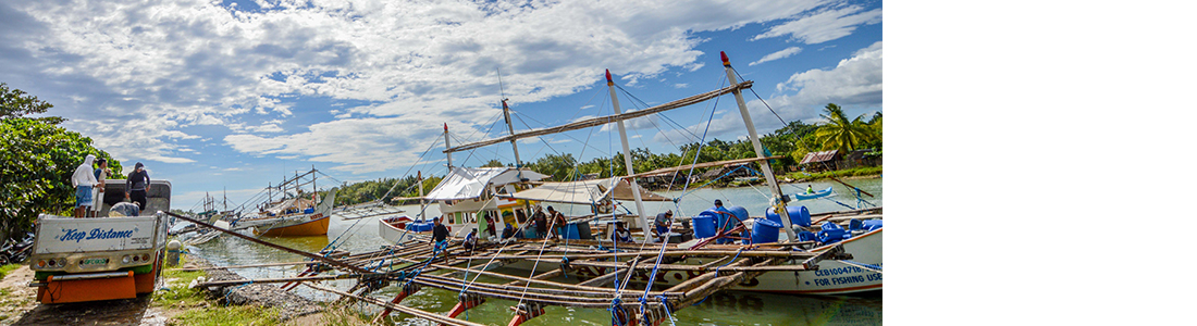
The major economic activity in the city is farming and fishing. This compliments with the key landscape of the city which is agriculture and the approximated 15 kilometer coastline which is rich in coastal resources. Trade and industry are closely related to the two major sources of economic activities.
The advent of cityhood in the year 2000, paved the way for the increasing number of commercial establishments and government agencies locating in the city. Consequently, employment opportunities became available. Migration to the city is also noticeable, brought about by the increasing livelihood opportunities locating in the city. Households earn an average of PhP 3,452 per month while rural households earn only about PhP 1,503 per month (based on the 2006 Local Socio-Economic Study).
Bayawan City has three (3) existing communal irrigation systems namely, Malabugas CIP, Mantapi CIP, and Tabuan CIP. One major CIP, the Bayawan CIP is on-going construction while two others are proposed, the Banay-Banay CIP and the Dawis CIP. These irrigation projects will irrigate an estimated service area of 2,500 hectares of agricultural lands. The major agricultural products are sugarcane, rice, corn and coconut. Only 2.3% (1,573 hectares) of the total land area is urban while 97.7% is rural and basically agricultural in land use. There are six identified watershed in the City namely, Bayawan, Sicopong, Ilog, Pagatban, Camayaan and Nalundan watersheds. These watersheds service the water needs of the six communal irrigation systems in the city and domestic potable water needs. The Sicopong, Ilog and Pagatban watersheds are also contributory to the water utilities of the neighboring municipalities and cities. In addition, part of the Bayawan and Pagatban Watersheds are habitat to the endangered spotted deer in Negros.
The proximity of Bayawan City to Negros Occidental makes it a vital social and economic hub that converge the political subdivision of Oriental and Occidental Negros. With the recent development on the Bayawan-Kabankalan Friendship Highway, which will connect and cut short the travel time to the Key Cities of Negros Occidental and Negros Oriental, linkages on trade, commerce, education and social services are expected to improve and strengthen. These linkages are beneficial not only to Bayawan City and Kabankalan City but to the Negros Island as a whole although separated in two provinces, two regions, and diverse cultures.
The development direction and guiding vision of the City of Bayawan is to make it as agri-industrial center and learning hub for environmental best-practices. Practically, most programs and thrust of the City Government is towards this mind set of the Bayawanon officials and constituency. The city although still in her early state of city hood takes the lead in the socio- political and economic development in the third district of Negros Oriental. It is identified as a major growth node for the Province of Negros Oriental.
Majority of the residents of the city are farmers. Migrants to this place tend to excel in trade and industries. Some are engaged in fishing. With the increasing number of commercial establishments and government agencies locating in the city, which require manpower resources, a considerable number of individuals are employed. Migration to the city is evident brought about by the cityhood of Bayawan. Urban households earn an average of PhP 3,704 per month while rural households earn only about PhP 1,659 per month (based on the FLUP Study 2002).
National Roads are 58.2 kilometers in length and 15 meters in width, 19 kilometers is concrete while 18 kilometers is asphalt and 21.2 kilometers is graveled. Provincial Roads are 27.9 kilometers and 10 meters wide. 4.7 kilometers is concrete and 23.2 kilometers is unpaved with gravel filling. The city streets have a total of 12.02 kilometers with a width of 12 meters all of which is already concreted. Barangay Roads have a total of 516.19 kilometers with a 6-meter width. Concrete road is 39.52 kilometers; unpaved with gravel filling is 116.16 kilometers while the remaining earth filled is 404.94 kilometers.
Bayawan City has no commercial seaport except the existing fish port where commercial fishing boats dock and do business.
Telecommunications facilities are provided by SMART Telecommunications, Globe Telecommunications, Sun Cellular, PLDT and Cruztelco. Major national dailies and local periodicals are available in local newsstands and major business establishments. Two local FM radio operate in the city. Internet cafes, calling centers, courier, telegraph and postal services are also present in the urban center. These telecommunication facilities are highly accessible in the urban area while the hinterland barangays have very limited access to these facilities.
Coming to Bayawan City from Dumaguete City through the Dumaguete South Road, from Bacolod City via Hinoboan or via Dawis Mabinay one has to contend with air-conditioned (available only for Bayawan City-Dumaguete City Route) and non-air-conditioned buses of Ceres Liner of the Vallacar Transit, Inc. Ceres Liner also offers direct trips to Cebu City via Dumaguete City. Likewise, the popular vehicles for hire also ply the Bayawan City-Dumaguete City and Dumaguete City-Bayawan City-Kalumboyan Route.
Around the city, one can take the foot driven tricycle the locals call, "Potpot". Inter barangay trips are serviced by motorized driven vehicle called "Pedicab" or the two-wheeled motorbike converted into a convenient passenger vehicle. For farther hinterland barangays, one can take public utility jeepneys or motorcycles-for-hire locally known as "habal-habal".
Political & Geographical Description
On December 23, 2000, through a referendum, Bayawan City became a fifth class Component City in the 3rd Congressional District of the Province Negros Oriental located in the southwestern portion. It is composed of twenty-eight (28) barangays with a total land area of 69,908 hectares, the largest in the province. Bayawan accounts for 13% of the province's total land area which is twice the size of the whole Siquijor Province (Island). It has a population of 114,074 with an average annual growth rate of 1.14%. Mabinay bound it to the north, Sta. Catalina to the east, Tanjay City to the southeast and Basay to the west. It also shares a boundary with Kabankalan City of Negros Occidental on the northwest. Bayawan City has a relatively short coastline of 15 kilometers west to east and comprising seven (7) coastal barangays running a stretch of almost 60 kilometers from the south coast going to the northernmost portion.
The City of Bayawan is subdivided into three development zones namely the urban area, sub-urban area, and rural area. The urban area constitutes only 2.3% (1,573 hectares) of the city's total area and contains the main institutional, commercial and central business district of the city. It functions as the main economic hub of the city with economic growth nodes established in strategically located barangays in the hinterlands. The sub-urban area is about 10,260 hectares or 14.7% of the total area and is set to contain the agro-industrial zones, industrial zones and human settlements. The existing industrial activity (lime plant), the establishment of saw mills, and the identified industrial zone in the area show the natural pattern of development. Residential zones are considered in the sub-urban area to provide settlements for the people in the commercial center and in the industrial zones. The rural area accounts for the large 83.1% of the city's total land area and is basically agricultural however; urban barangays are identified to contain a high level of commerce, trade being the economic growth nodes of the city. These growth nodes are singled out due to their strategic geographic location while other rural barangays are mainly agricultural production areas.
People & Language
Population 114,074 (2010 NSO Data) 2013 Projected Population 118,184 Population Density 1.63 Labor Force Ratio 56.58% Population Growth Rate 1.1 Male-Female Ratio 1:1.93 Dependency Ratio 46.92% Voting Population 58,000 No. of Household 22,471 Average Household Size 5.1 members Labor Force Population 64,852 Languages/Dialects Cebuano, Ilonggo, Kinaray-a, Tagalog Ethnic Groups Bukidnon, Cebuano, Ilonggo, Karay-a, Siquijodnon, Muslim, Boholanos Top Ten Religion Roman Catholic, UCCP, Baptist, Iglesia Ni Cristo, New Apostolic Church, 7th Day Adventist, Dios Amahan, Four Square Gospel Church, Born Again, Protestant
Annual Budget
Annual Procurement Plan or Procurement List
SEF income & Expenditure Estimates
Statement of Debt Service
Annual GAD Accomplishment Report
Statement of Receipts and Expenditures (SREs)
Quarterly Statement of Cash Flows
Items to be BID
Report of SEF Utilization
Trust Fund Utilization
Bid Results on Civil works and Goods and Services
Abstract of Bid as Calculated
20% Component of the IRA Utilization
Supplemental Procurement Plan
Manpower Complement
Unliquidated Cash Advances
Statement of Receipts Sources (SRSs)
Statement of Expenditures (SoE)
Local Disaster Risk Reduction and Management Fund Utilization
Bayanihan Grant to Cities and Municipalities
SEF Detailed Statement of Cash Flows
Statement of Indebtedness, Payments and Balances
Vision, Mission, Goals & Objectives
Performance Governance System
Organizational Structure
Department/Offices
Elected Officials
Barangays
Past Mayors/Officials
Devolution Transition Plan 2022-2024
Items to Bid
Request for Quotation
Supplemental/Bid bulletin
Bids Results on Civil Works
Bids Results on Goods
Abstract of Bids as Calculated
Bids And Awards Committee
Accreditation Process
Invitation for Public Auction
Citizen's Charter
Application Form for Business Permit
Application for Building Permit
Investment Code of 2017


